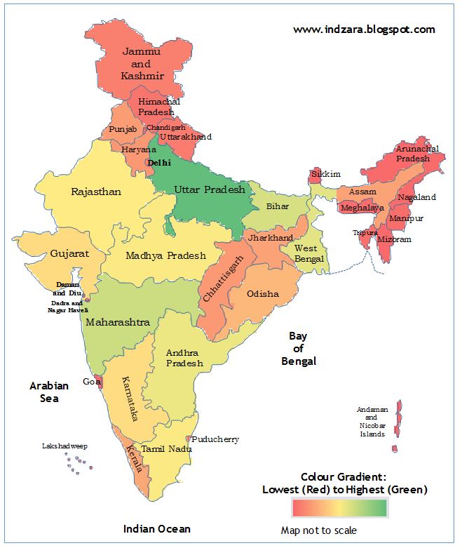
Geographic heat map – India (Excel template)
I was looking for a way to present/visualize state level data on an Indian map. I was not able to get that from the Bing maps application for Excel.
I am sure there are paid applications that might provide this functionality. I think this is a very basic need and I decided to prepare a simple template that can help create geographic heat maps for India.
India Heat Map Excel Template
Download
If you would like to create editable map of India in excel free download the India Heat Map Excel Template (Telangana added in June 2014)
Please see below, a quick 5 minute demo of this template.
How to use this India Heat Map Excel Template?
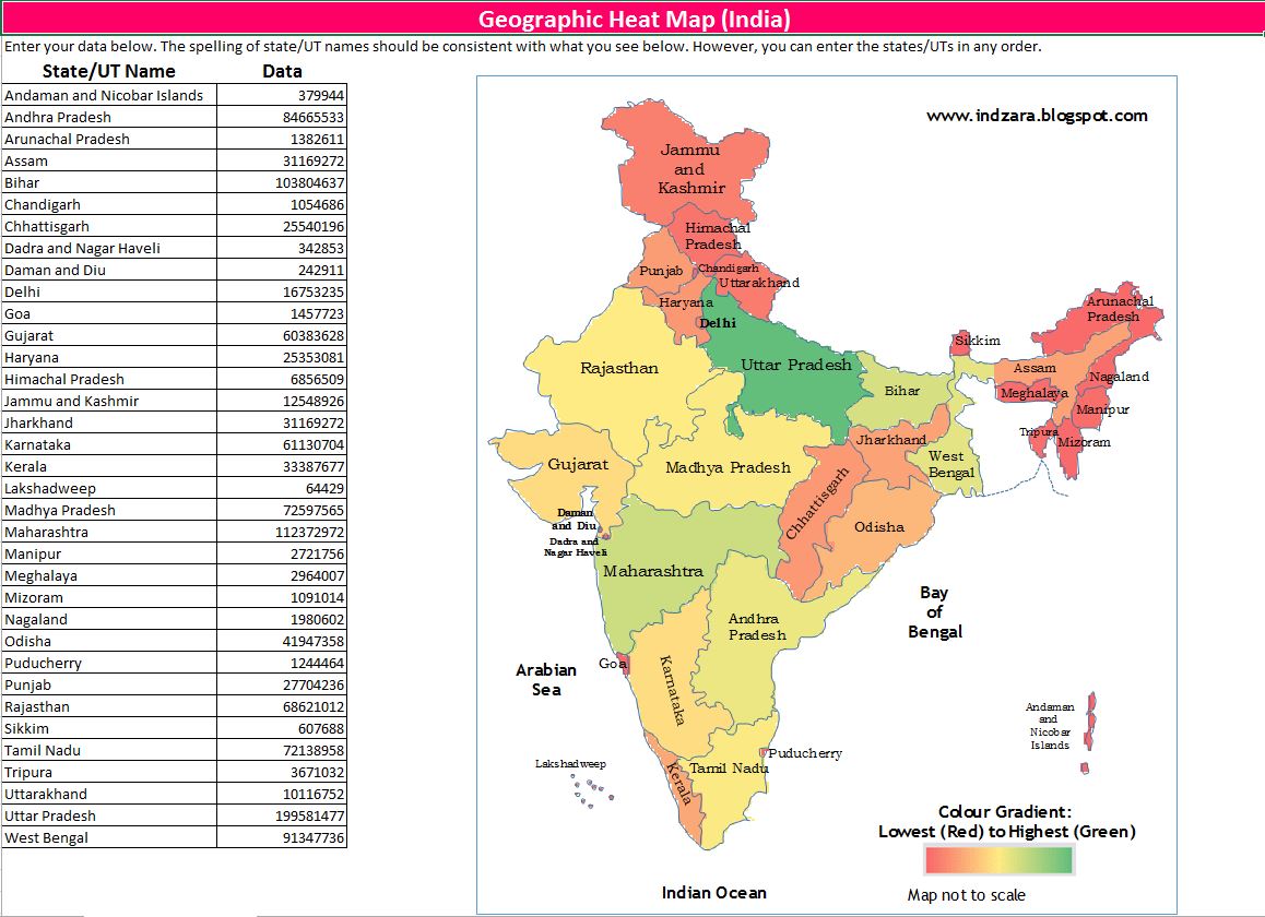
- Enter your (numeric) data in the data column and the map image on the right gets updated.
- Please make sure that the state (or union territory) names you enter in column A are spelled the same way as they are
- They are currently ordered alphabetically. However, you may choose to enter them in any order.
- You can print the sheet if needed
- You can copy the image and paste it in other applications such as Microsoft Word or PowerPoint
You can also use this template to showcase the position of one specific state.
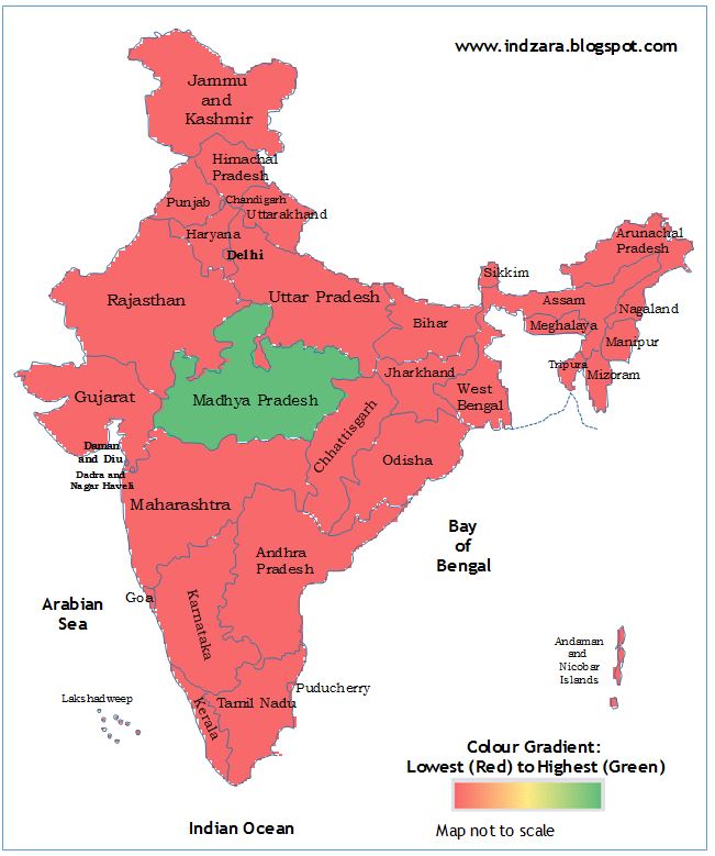
For the illustration above, I entered a positive number (1) for Madhya Pradesh and deleted the data for all other States/UTs.
How is the heat map generated?
The India Heat Map Excel Template has a hidden worksheet where the outline of India and States/Union territories were drawn with the cells pointing to corresponding data. Conditional formatting has been used to create the heat map.
If you would like to change the color gradient, read this article.
If you know of better ways to do this or if you use any application to create such an excel map chart India heat maps, please share your thoughts.
183 Comments
Can we add data labels to the map?
Thank you for using our template.
Yes, you can add data labels by unhiding the hidden Data tab and add your requirement to reflect inside the map. Requesting to contact support@indzara.com for more support.
Best wishes.
Hello,
Is it possible to reverse the color gradient? Red for highest and green for lowest? Or use different color scheme all together?
Thank you for using our template.
Yes, you can change the color scheme through the following steps.
1. Unhide hidden Data tab by right clicking the tab name.
2. Click any cell inside India.
3. Click Home ribbon.
4. Select Conditional formatting.
5. Select manage rule.
6. Click edit rule and change the color according to your requirement.
Best wishes.
Hi,
Thank you for this heat map file. I use it very often. However, I would like to know how i can edit or modify “www.indzara.com” from the top of the map.
Regards
Thank you for using our template and you are welcome.
You can unhide the Data tab to change the text box containing http://www.indzara.com.
For more details please email to support@indzara.com.
Best wishes.
Dear Sir,
Thanks for the Heat Map.
I would like to change the font colour of the state’s name as when i select the gradient which appears to be darket that time the font colour being black doesn’t reflect properly.
Request your support.
You are welcome.
You can unhide the hidden sheet and select the particular text box to change the color of the text. If you are unable to change the color, requesting to contact our support team at support@indzara.com to help further.
Best wishes.
Hi, Can we have a heat map of all the cities of India?
Hello
We are in the process of developing heat maps for different states like Karnataka, Maharashtra etc.,. We will release them soon. But currently we are not in plan of developing a heat mat of a city with its territory like
Bangalore, Chennai etc.,. However we do take customization project for a fee, so if you provide a city image with its territory to support@indzara.com, we can provide an estimate of work.
Thanks
The colour gradient is not available in the downloaded file ..only text is there ……from lowest to highest
We regret the inconvenience caused but we are unable to replicate from our end. Hence, requesting to share the downloaded sheet to support@indzara.com along with your System OS (Mac/Windows) and Excel version used.
Hi
The borders and actual map get messed up and disproportional as soon as I open the downloaded file. The same happens if I open as xls, xlsx or csv. Any suggestions on how to solve this?
Our support team will respond to you shortly.
In the meantime, if you require any support on our product, requesting you to send an E-Mail to support@indzara.com
Hi, When is the statewise heat map being released.
Thanks for your message.
The wait will not be long. We will release them soon.
Best wishes
Thank you
Can we have heat map for Telangana states with 33 districts
Hello
We are in the process of developing heat maps for different states. We will release them soon.
Thanks